These were locations for possible swims to be explored 4-7 Oct 2019 in my final monthly swim trek in East Anglia. Read more in the Swims section of this website.
Ordered by rivers, in flow order (East to West): Little Ouse; Lark; Wissey
See Itinerary and Quick Report of trip
This was a personal trip and not part of the projects. However this last trip of the six months was special because many of the swim places could be part of two projects to discover the history and promote safe and environmentally friendly outdoor swimming into the future, including surveying for places, training sessions, and finding out about traditional swimming places, to be funded by the National Lottery Heritage Fund, as part of a wider set of projects about the watery landscape of Breckland. You can read more about this on the separate OS Brecks section of this website
Please note: all swims are at our own risk. Including a location does not indicate a recommendation, or that it is ‘safe’; we must each do our own risk assessment. Swim Safety info and links on this website.
Most swims are most easily reached by car; some have no public transport route. Some are near railway stations, though. I’ve indicated this at the end of most entries.
Locations also on a Google map
Little Ouse
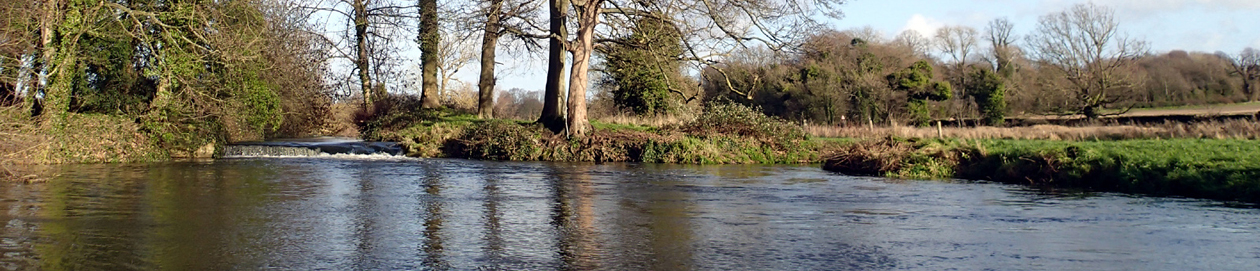
Knettishall Heath
Free car park, short walk to river, shallow beach entry, slightly deeper pool by weir. Toilets and barbecue pits, gate closed 5 pm even in summer.
Knettishall Heath TL 95554 80751 0.87237239 52.389847 IP22 2TE
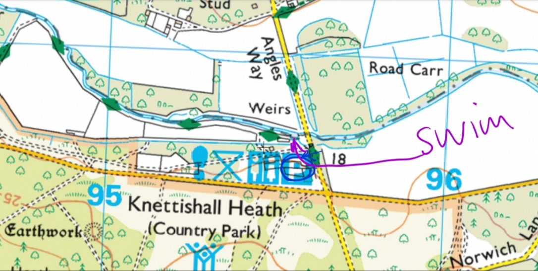
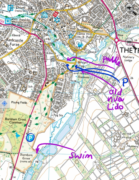
Barnham Cross Common
Take footpath from car park to small and shallow pool in river, slightly deeper far side. Cows sometimes in meadow. Can walk from Thetford. Height barriers to be installed soon.
Barnham Cross Common TL 86806 80997 0.74410915 52.395111 IP24 3DZ
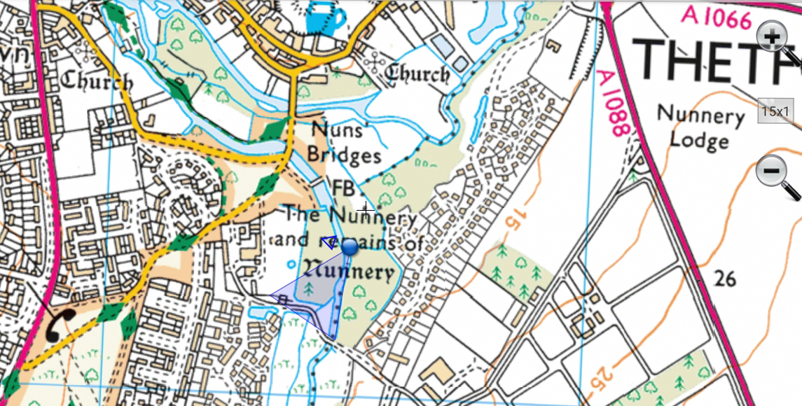
Nuns’ Bridges/Thetford Lido river pool.
Parking right by the bridge and the old lido, also on the other side of the road by the river, also in the BTO car park just a little way away, also in town. Railway station. No swims here, as the water is shallow and silted up in the now derelict lido. Below Nuns Bridges it is possible to paddle.
Nuns’ Bridges TL 87398 82457 0.7536149 52.408014 IP24 2EP
Two Mile Bottom
Car park on north side of A road, cross with care, walk past the Scout Camp down to the river. Not very deep, but shallow entry for paddle, dips possible, eg under the footbridge.
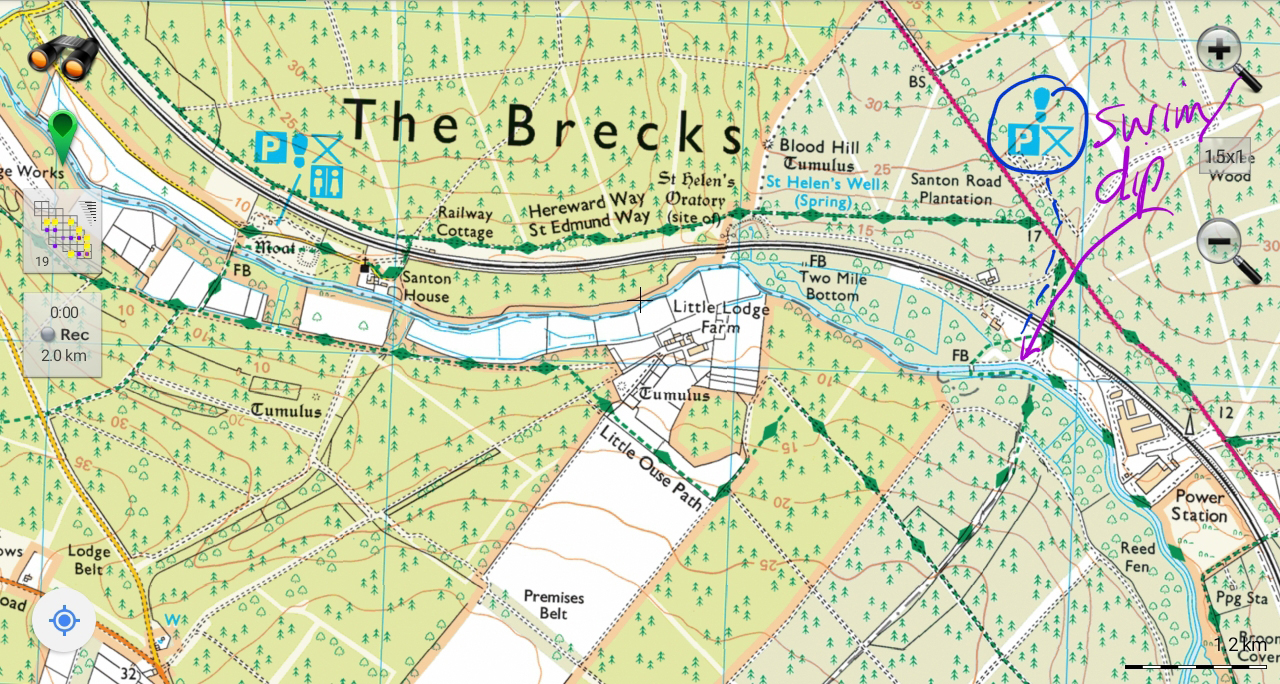
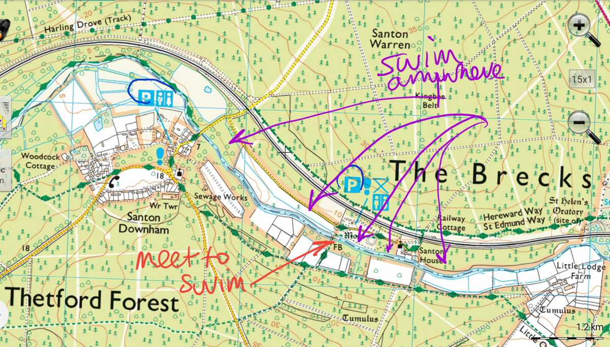
St Helen’s picnic place, Santon Downham.
Car park, toilets (currently closed), very close to river, shallow entry and beaches, some deep pools. Long stretch with footpath and many beaches and pools. Water can be low (it was in October) and it can be weedy (not too bad in autumn, winter, spring). You can also park at the Forestry Commission offices in Santon Downham where there are toilets. Bus from Thetford.
St Helen’s Picnic Site TL 82533 87288 0.68482161 52.453044 IP27 0TS
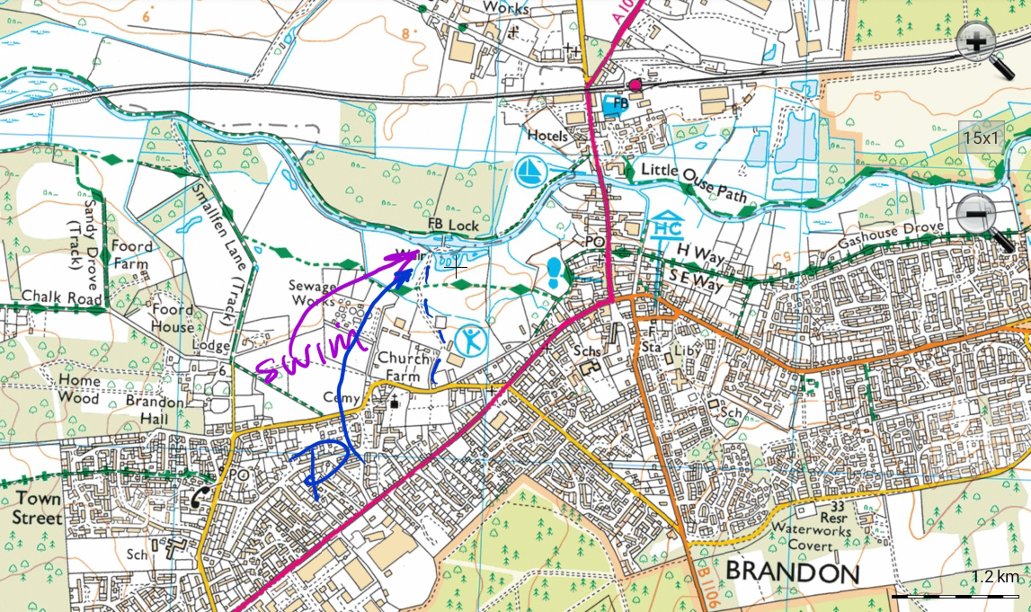
Brandon Staunch
Drive to the leisure centre, then take the road beyond that car park right down to the river. There is an overhead barrier but it is not locked until 9 PM/10 PM (in summer, might be different times in other seasons) and you can open it yourself if necessary. There is another gate that isn’t locked. Enter the river by a slipway. Shallow entry, soon deeper. Be aware of and best to keep away from the weir. Occasional boats. Brandon has a railway station, short walk along the riverbank.
Brandon Stanch TL 77785 86693 0.61470866 52.449267 IP27 0EN
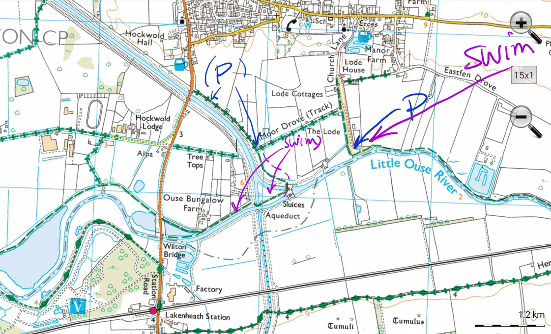
Hockwold Common On wild swim map
Either park in the village, near the church/ pub/ cross, and walk down, or drive down. Go down Church Lane, carry on until the tarmac stops then fork left to take the track down to the common (can be a little bit rough). You can park right by the river. Shallow chalk entry, deep water stretching for miles in either direction. Occasional boats. (Also shown is Hockwold Sluice.)There is a railway station at Lakenheath, bit of a walk away. Bus from Brandon
Moor Drove, Hockwold TL 73582 87289 0.55324316 52.455968 IP26 4JL
Lark
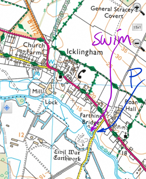
Icklingham
You can park in a small layby right by the river, or another layby a little further along the road. Shallow but rocky entry, small deep pool by Farthing Bridge, area also known as Three Bridges. Mentioned by Roger Deakin. Bus from Mildenhall.
Icklingham TL 75853 72867 0.57905674 52.325719 IP28 6QD
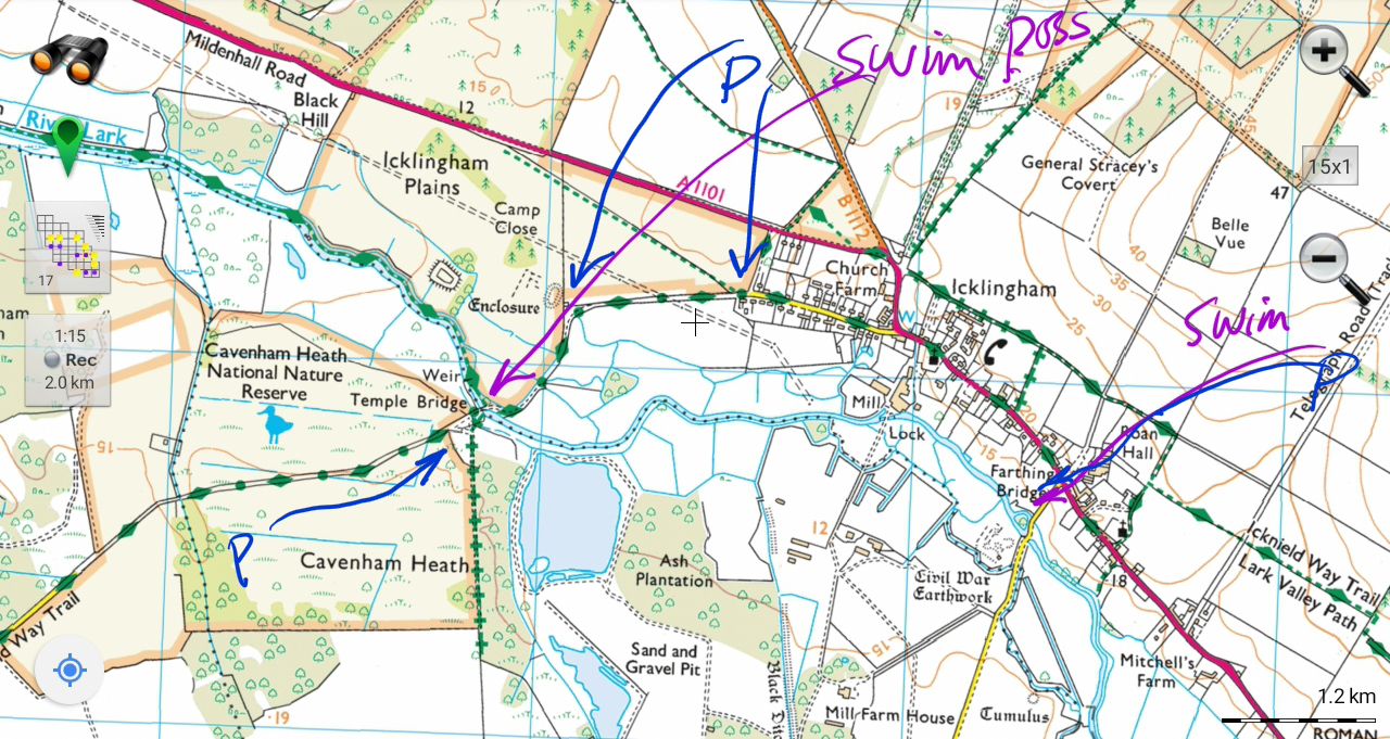
Cavenham
Park at the end of West Street, Icklingham, or further down the track (don’t block farm field entrances). Or at Cavenham Heath, or along the track to Temple Bridge. People swim in pools above and below the weir. Cavenham TL 77329 72623 0.60055733 52.323055 IP28 6PE
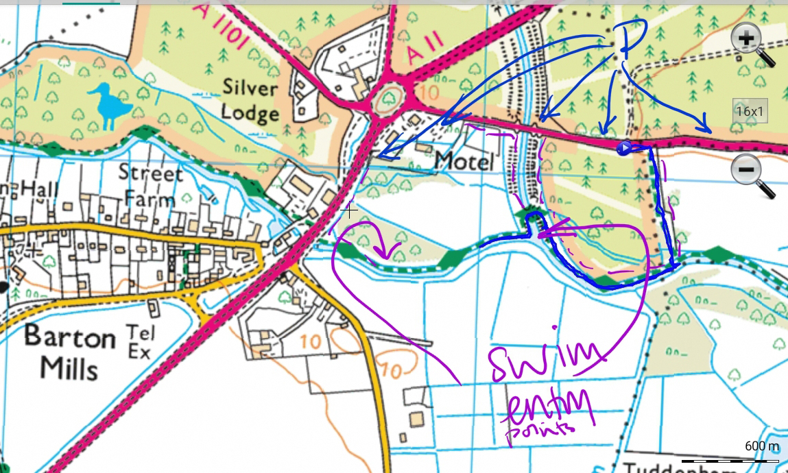
Barton Mills
Where the cut-off channel meets the river Lark. Entry point into the cut-off channel is muddy and it is shallow until you reach the main river, but swimmable. Or walk along the path towards the A11 and find a place to enter. There can be duckweed, but not too bad (October).
Various parking spots, note that walking from some of them, particularly the motel, needs care as the roads are busy. If you walk along the A11 you can be behind a barrier. The easiest is at the end of the cut off channel, which you can walk beside. A nice walk – but nettly and a bit overgrown – is from layby a little further away, through a wood and along the riverside path. Bus from Bury St Edmunds or Norwich.
Barton Mills TL 73125 73857 0.53957462 52.335475 IP28 6AS
Mildenhall, Lark.
Two possible places. One not yet looked at – the cricket pitch. It looks as if you can park and walk to the river to find an entry point.
We explored Jubilee Field – the east spot on this map – and there are several entry points. Park in the free car park behind Sainsburys, 2.1m barrier. Bus from Bury St Edmunds or Norwich.
UPDATE: Mildenhall along to Barton Mills location info now on website, https://www.imogensriverswims.co.uk/blog/places/mildenhall-and-barton-mills/
Mildenhall Cricket Club TL 70589 74313 0.50262451 52.340363 IP28 7QJ

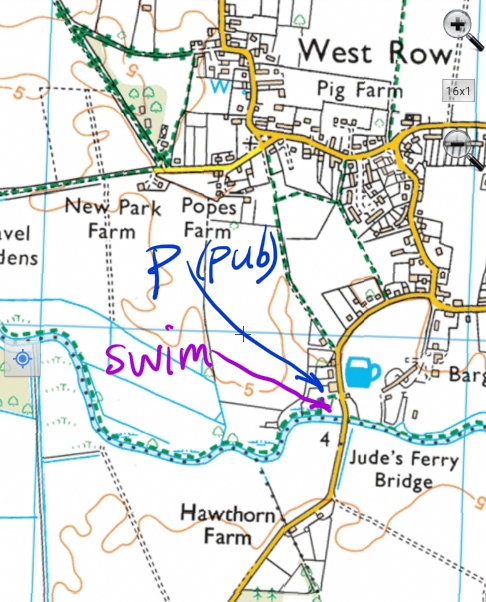
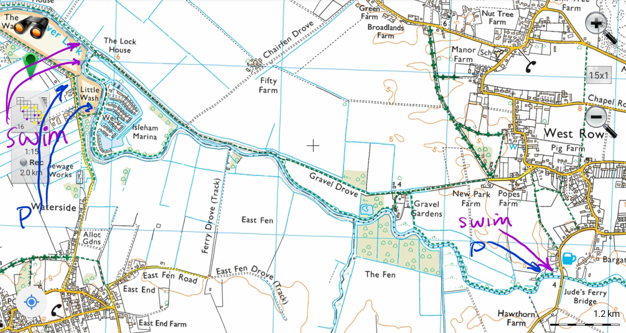
Jude’s Ferry, Ferry Lane, West Row
If you park at the Jude’s Ferry pub it would be reasonably expected that you would eat or drink there. They are welcoming to swimmers. It might be busy Sunday lunchtime, and if not busy it can be closed on Mondays. The pub has a riverside jetty. You can climb down into the water from either end – not for those less able to do so. The water can be very clear, sometimes weedy, fairly deep.
Jude’s Ferry, Ferry Lane TL 67714 74822 0.46072841 52.345819 IP28 8PT
Isleham
You can park by the entrance to the marina, and have a quick dip, despite signs, shallow entry, small pool, or swim further downstream. Or park by or walk round to Wash Common, and walk round by the river. There is a shallow possibly muddy entry beach. Or go to the main river where you can get in next to a pipe. The water is deep, but might be weedy. There are sometimes boats. Bus from Newmarket.
Fen Bank, Isleham TL 64914 75730 0.42010903 52.354825 CB7 5ZD
Soham Tunnel Drove
Details are available to members of the Outdoor Swimming in Breckland Facebook group)
Wissey
Hilborough Ford
At the bend in the A1065 take the track to the river, a few parking places. A lovely place for a paddle – shoes needed. It is possible to find a deeper pool downstream for a dip. Bus possible.
HilboroughFord TF 83389 00917 0.70490599 52.575148 IP26 5BS
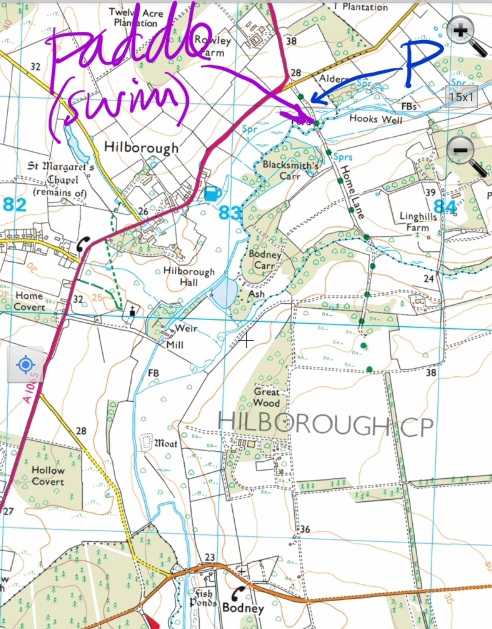
Ickburgh
Take Ashburton Road off the A1065 all the way to the end, over one river and on to the next. Either park by the river pool or at the junction with another track a little further on. A small deep area of the pool next to the weir – but be aware that the weir can pull you under when the water is fairly fast – and stony shallow areas for paddling and exploring downstream. Bus to Mundford from Thetford then walk.
Buckenham Lane, Ickburgh TL 83095 95039 0.69733143 52.522462 IP26 5JQ
Didlington
Park at the junction or right on the bridge. You can enter the water by the bridge, or walk upstream to the sluice where there is a deep pool. The water is quite low at the moment. The land is private, though many swim there in summer and have done so for generations.
Foulden Road, Didlington TL 77073 96724 0.60956955 52.539578 IP26 5NJ

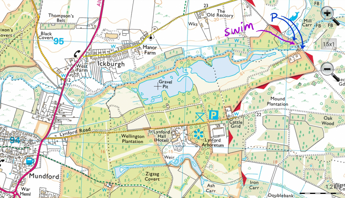
A lake near Mundford
Details are available to members of the Outdoor Swimming in Breckland Facebook group). Nearby café, in Mundford, Brown’s – on Facebook, @BrownsKitchen, Mundford Norfolk IP26 5TH, 01842 879888
A lake near Watton – explored
Details are available to members of the Outdoor Swimming in Breckland Facebook group)
Please note: all swims are at our own risk. Including a location does not indicate that it is safe; we must do our own risk assessment. Swim Safety info on this website.
I have included maps on this page to help people find spots where I have swum. You are welcome to download these to help you find these places for yourself, but if sharing I would prefer you to include the link to the page so that people can see the information in context. It’s a good idea to always include a phrase such as: sharing a location does not indicate that it is safe; we must do our own risk assessment, and we all swim at our own risk. You are not welcome to download or share this material for purposes other than it was designed for, or to misrepresent information from this website.
[swim log 114.5-128, etc]